Ukraine has 132,000 km² of land that may hold mines and unexploded ordnance. Most of it is checked the old way: one deminer, one detector, 10 to 50 square metres a day.
At that pace, Ukraine's own national strategy talks about up to 70 years. That's farmland that can't be sown, roads that can't be used and villages people can't move back to — for two generations.
SubTerra Intelligence exists to change that pace. This is how we got here, where we are, and where we want to go.
It started with a self-driving robot
I've worked on this problem since 2023. My first attempt was an autonomous robot: a self-driving vehicle that would cover the fields on its own and detect mines as it went. The idea was right. The hardware wasn't. It couldn't do what we needed, and we shut it down.
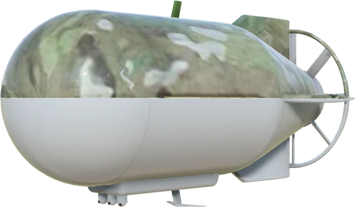
So it started with a self-driving robot, and now it's an airship. That failure was the most useful thing that happened, because it taught me two things. First, you don't win on the ground — you win from above, where you can cover large areas without touching them. Second, no single sensor is enough. Every tool on the market works in isolation, and nobody gets a shared picture of what's actually down there.
Three companies, one platform
In September 2026 we founded SubTerra Intelligence as a joint venture between three companies. Each brings the part the others don't have:
- Anumá Aerospace — the airship. Led by co-founder Jamie Little, Anumá has developed a US-patented partial-vacuum lift. It lifts with vacuum instead of helium or hydrogen, and the principle has been built and flight-tested.
- Genetix Computing — the software. Led by co-founder Claus Jordan, Genetix brings Context Core: software that cross-checks every sensor reading against the others and against known, validated cases. It doesn't guess. If a reading matches a validated case, it's classified. If it doesn't, it goes to a human expert, and their answer is added to the library for good.
- Wieder, Inc. — leading the venture. My company. I lead SubTerra and bring the commercial side, the funding and the relationships in the field.
Under the airship sit up to nine types of sensor from established manufacturers — ground-penetrating radar, magnetometer, LiDAR, thermal and others — scanning the same ground at the same time. Context Core turns all of it into one map.
Why the data is the real asset
Anyone can buy the sensors. What can't be bought is years of verified answers about what a given signal in a given soil actually turned out to be. Every survey makes the library bigger, and every expert decision makes the next survey better. That's what we're building, and it only grows by doing the work.
What clearance teams get from us is not another tool to operate. It's a finished map: where the threats are, marked and prioritised, so they clear the right ground first instead of searching blind.
Where we are today
We're honest about the stage. The lift principle is built and flight-tested. The software exists and is being adapted to read sensor data. The licences that give SubTerra the airship and software technology are signed. The full-scale airship has not been built yet, and nothing has been proven in the field. In technical terms we're at TRL 4–5.
We're now raising our first funding round to change that.
What happens next
- Build. The first airship, with the sensors integrated, tested on ranges with known targets.
- Prove. Field tests in Ukraine, with our maps checked against what clearance teams actually find on the ground.
- Accredit. Get the method accepted under Ukraine's national mine action standards, so our maps count as survey evidence.
- Deliver. First paid contracts mapping farmland for clearance.
Where we want to go
The goal is a fleet of airships mapping Ukraine fast enough to bring that 70-year horizon down to something a generation can live with — starting with farmland, then the rest of the contaminated land.
Ukraine is the first market, not the only one. Mines and unexploded ordnance affect 58 states and territories.
The commercial road beyond demining
The airship, the sensors and the software aren't limited to mines. The same platform could serve paying customers in peacetime markets too. The platform, the data and the team stay the same — each step adds customers, not a new company.
- Unexploded ordnance in Europe. Europe still builds on top of the Second World War. Germany alone has an estimated 100,000–300,000 tonnes of wartime munitions in the ground, and the state of Brandenburg has 580,000 hectares of suspected land. A survey is routine before building in Germany, the Netherlands, Belgium and the UK — and solar parks, onshore wind, grid lines and rail are exactly the large areas and long corridors an airship is built for.
- What's under the ground. The same sensors and software could map buried pipes and cables, and survey for minerals.
- Agriculture. Once a field is cleared, it could be mapped for crop health and soil variation — and the airship could spread fertiliser from the air, with no tractors and no soil compaction.
- Inspection and monitoring. Pipelines, power lines and rail, wildfire watch, and methane leaks over large areas.
- Security and civil protection. Long-endurance coverage for border security and civil protection. Humanitarian first — but dual-use by design.
But first things first: one airship, one field, one verified map. Everything else is built on that.
Interested in SubTerra Intelligence — as an investor, partner or future customer? Get in touch, or read more at subterraintelligence.com.